XF Vision
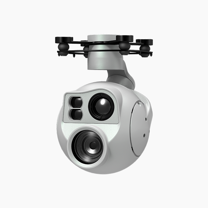
D-125AI Intelligent Multi-sensor Spherical Pod
D-125AI Intelligent Multi-sensor Spherical Pod
Couldn't load pickup availability
The D-125AI equips with a high accuracy 3-axis nonorthogonal pod, an 120x hybrid zoom camera and a long-wave thermal camera, which can provide visual and infrared images simultaneously. Thanks to the laser range finder, the D-125AI can provide the location of a target and the distance to it that improves working efficiency.
The D-125AI have AI multi-object detection and tracking function. The gimble camera can intelligently identify the persons and vehicles in the image, and constantly track one of them.
The D-125AI can be mounted tool-lessly onto multiple carriers, whether downward or upward. With the GCU and the Dragonfly software, user can watch the image from the camera and control the pod real-timely on a computer.
Characteristics
· Features AI multi-object detection and tracking, which can constantly track one of the persons and vehicles intelligently identified in the image.
· Carries an 120x hybrid zoom camera, a thermal camera and a laser range finder.
· Low-profile spherical shape and 3-axis nonorthogonal mechanical stabilized structure, minimize the gyration radius and the wind resistance of the pod. The D-125AI is able to spin continually around its yaw axis.Supports network, UART and S.BUS control.
· Supports both private protocol and MAVlink protocol.
· Thanks to the Dual-IMU complementary algorithms with IMU temperature control and carrier AHRS fusion, the D-125AI provides a stabilization accuracy at ±0.01°.
· Can be mounted onto multiple carriers, whether downward or upward.
· With the Dragonfly software, user can watch the image and control the podwithout protocol ducking.
· Photos and videos can be downloaded online through the "Gallery" function of the Dragonfly software.
· With the customized QGC software, all the functions of the pod can be achieved in conjunction with an open source autopilot.
· Screen supports overlaying OSD information such as latitude, longitude and altitude. Image supports shooting point coordinate EXIF save. Video stream supports SEI stacking.
· 20~53 VDC wide voltage input.